


3,7 km | 5,2 km-effort
![Randonnée A pied Kryštofovy Hamry - [Ž] Přísečnice - Kryštofovy Hamry (CZ/D) - Photo](https://media.geolcdn.com/t/1900/400/03c08e34-bb16-4dca-b0b7-852ffa6612cc.jpeg&format=pjpeg&maxdim=2)

Tous les sentiers balisés d’Europe GUIDE+


Application GPS de randonnée GRATUITE
 SityTrail
IGN / Instituts géographiques
SityTrail World
Le monde est à vous
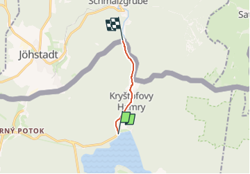
Randonnée A pied de 3,6 km à découvrir à Severozápad, Ústecký kraj, Kryštofovy Hamry. Cette randonnée est proposée par SityTrail - itinéraires balisés pédestres.
Randonnée créée par cz:KČT.
![Randonnée A pied Kryštofovy Hamry - [Ž] Přísečnice - Kryštofovy Hamry (CZ/D) - Photo 1](https://media.geolcdn.com/t/2048/auto/c4042fff-8948-41c6-8953-2ca03988a4fd.jpeg&format=jpg&maxdim=0 "Randonnée A pied Kryštofovy Hamry - [Ž] Přísečnice - Kryštofovy Hamry (CZ/D) - Photo 1")
![Randonnée A pied Kryštofovy Hamry - [Ž] Přísečnice - Kryštofovy Hamry (CZ/D) - Photo 2](https://media.geolcdn.com/t/2048/auto/9c650b17-599c-4651-aeb5-45a22ad3594c.jpeg&format=jpg&maxdim=0 "Randonnée A pied Kryštofovy Hamry - [Ž] Přísečnice - Kryštofovy Hamry (CZ/D) - Photo 2")
![Randonnée A pied Kryštofovy Hamry - [Ž] Přísečnice - Kryštofovy Hamry (CZ/D) - Photo 3](https://media.geolcdn.com/t/2048/auto/51e3d790-3009-4ad9-a573-7780f4a3b3a6.jpeg&format=jpg&maxdim=0 "Randonnée A pied Kryštofovy Hamry - [Ž] Přísečnice - Kryštofovy Hamry (CZ/D) - Photo 3")
![Randonnée A pied Kryštofovy Hamry - [Ž] Přísečnice - Kryštofovy Hamry (CZ/D) - Photo 4](https://media.geolcdn.com/t/2048/auto/f70232fe-1d09-4c8d-b508-c2d60c298e99.jpeg&format=jpg&maxdim=0 "Randonnée A pied Kryštofovy Hamry - [Ž] Přísečnice - Kryštofovy Hamry (CZ/D) - Photo 4")
![Randonnée A pied Kryštofovy Hamry - [Ž] Přísečnice - Kryštofovy Hamry (CZ/D) - Photo 5](https://media.geolcdn.com/t/2048/auto/24931c8d-6296-438a-b7cb-2ee6666c08cd.jpeg&format=jpg&maxdim=0 "Randonnée A pied Kryštofovy Hamry - [Ž] Přísečnice - Kryštofovy Hamry (CZ/D) - Photo 5")
![Randonnée A pied Kryštofovy Hamry - [Ž] Přísečnice - Kryštofovy Hamry (CZ/D) - Photo 6](https://media.geolcdn.com/t/2048/auto/d12d6baf-4f8f-4b09-a1b3-055e23f98322.jpeg&format=jpg&maxdim=0 "Randonnée A pied Kryštofovy Hamry - [Ž] Přísečnice - Kryštofovy Hamry (CZ/D) - Photo 6")
![Randonnée A pied Kryštofovy Hamry - [Ž] Přísečnice - Kryštofovy Hamry (CZ/D) - Photo 7](https://media.geolcdn.com/t/2048/auto/7eb67750-3340-41e8-82ae-e7cdd7572120.jpeg&format=jpg&maxdim=0 "Randonnée A pied Kryštofovy Hamry - [Ž] Přísečnice - Kryštofovy Hamry (CZ/D) - Photo 7")
![Randonnée A pied Kryštofovy Hamry - [Ž] Přísečnice - Kryštofovy Hamry (CZ/D) - Photo 8](https://media.geolcdn.com/t/2048/auto/bca9b708-b568-415f-b5fa-2beb276f50cb.jpeg&format=jpg&maxdim=0 "Randonnée A pied Kryštofovy Hamry - [Ž] Přísečnice - Kryštofovy Hamry (CZ/D) - Photo 8")
![Randonnée A pied Kryštofovy Hamry - [Ž] Přísečnice - Kryštofovy Hamry (CZ/D) - Photo 9](https://media.geolcdn.com/t/2048/auto/6ae014a5-e26c-4708-a2ab-3ed63a2eacc9.jpeg&format=jpg&maxdim=0 "Randonnée A pied Kryštofovy Hamry - [Ž] Přísečnice - Kryštofovy Hamry (CZ/D) - Photo 9")
![Randonnée A pied Kryštofovy Hamry - [Ž] Přísečnice - Kryštofovy Hamry (CZ/D) - Photo 10](https://media.geolcdn.com/t/2048/auto/03c08e34-bb16-4dca-b0b7-852ffa6612cc.jpeg&format=jpg&maxdim=0 "Randonnée A pied Kryštofovy Hamry - [Ž] Přísečnice - Kryštofovy Hamry (CZ/D) - Photo 10")

A pied
A pied
A pied
A pied